 |
|
|
|
|
|
The name Packard's Corner refers to Packard's Sales Stable and Riding School which was located in the vicinity of Commonwealth Avenue's intersection with Brighton Avenue from 1885-1920. The Packard name was perpetuated by the important early 20th century Boston businessman and political figure Alvan T. Fuller who built the Packard Motor Car Company building at 1079-1089 Commonwealth Avenue in several stages between 1909 and 1930. This area has significant historical associations with Boston's early 20th century automobile industry. It was part of a larger "auto mile" of office buildings, show rooms and automobile related businesses which stretched from Kenmore Square to Packard's Corner along Commonwealth Avenue. The Detroit based architect Albert Kahn designed the Packard Motor Car Company Building constructed at 1079/1089 Commonwealth Avenue between 1909 and 1915. 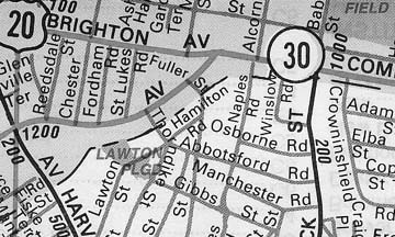 This area is also distinguished by the St. Luke's and St. Margaret's Episcopal Church complex at 46 Brighton Street which evolved between 1895 and 1913. Encompassing a Jacobethan half-timbered chapel and rectory designed by Francis R. Allen along with the 1913 Tudor Gothic church structure by Berry and Davidson, St. Luke's is one of Allston-Brighton's little known gems. Finally the late 19th/early 20th century single and two family housing along Chester, Reedsdale and Linden Streets represents a less ornate continuation of the slightly older, larger scaled housing of the Garden Street area, north of Brighton Avenue. As late as the 1880s, Packard's Corner was sparsely populated, despite the fact that Brighton avenue (the Mill Dam) had been set out along the northern edge of this area as early as 1825. In fact, Harvard Avenue, located just one block to the west of this area, was part of the old Roxbury Highway, set out as early as 1638, to connect Cambridge with Boston, via the Great Bridge across the Charles River (1663). This lack of development in an area seemingly well served by venerable transportation arteries had everything to do with the inhospitable terrain located between Brighton Avenue and the Brighton/Brookline borderline. Late 19th century Suffolk Co. Atlases indicate that most of this area was part of Brookline. In 1890, boundary adjustments favorable to Allston-Brighton were instituted during the setting out of Commonwealth Avenue, shifting the line a few yards to the south. Prior to small scale filling operations and culvert construction during the 1890's, Packard's Corner was traversed by several streams, most notably the Smelt Brook which flowed between the Charles River and a pond located on the south side of Commonwealth Avenue, in the vicinity of Naples Road. Smelt Brook or Smelt Inlet as it was sometimes called served as a natural boundary between Brighton and Brookline. A second pond and a cedar swamp (in the vicinity of Commonwealth and Harvard Avenues) made development all but impossible until the introduction of steam shovels, steam rollers and macademized roads during the second half of the 19th century. The oldest thoroughfare within the boundaries of the Packard's Corner study area is Brighton Avenue which was set out by 1825 as an extension of the road over the Mill Dam (Beacon Street). The Mill Dam's construction represents a project of momentous importance within the annals of Boston history. Thrust across the Charles River Basin between 1814 and 1820 from Charles Street, Beacon Hill to Sewall's Point, Brookline (present day Kenmore Square) this dam was intersected by a perpendicular dam following the path of present day Massachusetts Avenue. The milling operations bordering the two causeway-enclosed basins soon proved to be a dismal failure but the highway atop the east-west causeway, later Beacon Street, provided a more direct route to Brookline and Brighton, opening these towns to new commercial and residential development possibilities. Due to the Mill Dam's construction, Brookline began to develop as an elite suburban area during the 1830s and '40s. Whereas in Brighton, despite the Mill Dam extension road offering more direct access to Boston, the presence of the famed Cattle Market acted as deterrents to the development of suburban enclaves for the well-to -do commuter. Sidney's "City and Vicinity of Boston" map of 1852 shows only two houses bordering the south side of Brighton Avenue between Harvard Avenue and Brookline. The Mill Dam extension road consisted of three segments: the segment of Commonwealth Avenue between Kenmore Square and Brighton Avenue, Brighton Avenue between Packard's Corner and Union Square and the segment presently called North Beacon Street between Union Square and the bridge to Watertown. During the 1840s,the Gardener Street area north of Brighton Avenue was set out with a modified grid street system adjacent to the Boston and Worcester Railroad which had been set out in 1832-34. Residential and commercial development south of Brighton Avenue, east of Harvard Avenue did not begin until the completion of Commonwealth Avenue in 1893 and even at that, the recession of the mid 1890's precluded significant housing starts until after the turn of the century. Nevertheless, the 1884 Olmsted plan for Commonwealth Avenue along with its early 1890s construction, marked the real beginnings of Packard's Corner as an important focus for commercial activity and apartment house construction in eastern Allston -Brighton. Frederick Law Olmsted (1822-1903) was the founder of the profession of landscape architecture in North America. Born in Connecticut, Olmsted is perhaps best known (together with Calvert Vaux) for his planning of Central Park in New York City during the 1850s. Other highlights of Olmsted's career included Prospect Park in Brooklyn, New York; the campus of Stanford University in Palo Alto, California, and Boston's Emerald Necklace park system. Commonwealth Avenue in Allston-Brighton represents a major Boston development project of the 1880s and 1890s. Backed by six Boston businessmen, including Isaac Pratt, Ebenezer Francis and Charles Francis Adams Jr., this group proposed to build a 200 foot-wide roadway with a central park and bridal path, flanked by macadamized driveways. Originally called "Massachusetts Avenue", the segment of Commonwealth Avenue, within Brighton, extends from Brighton Avenue near the Brookline line to the Chestnut Hill Reservoir where it was linked to Beacon Street, Brookline, thus completing the "Chestnut Hill Circuit". This circuit, in turn, was connected to the Fens segment of Boston's Emerald Necklace park system by Audubon Road. Neither Commonwealth Avenue nor Beacon Street was a parkway in Olmsted's sense, since commercial traffic was permitted along with pleasure vehicles. Brookline's Beacon Street was developed during the mid 1880s before the Commonwealth Avenue section of the "circuit" was completed in Brighton. Encouraged by the brisk and profitable land sales along Beacon Street, Commonwealth Avenue backers and real estate magnates such as Ebenezer Francis and Charles Francis Adams Jr. offered the city free land for this thoroughfare's construction, but the city was slow to initiate the project. By the time of Commonwealth Avenue's completion in 1893, the economy had suffered a sharp downturn resulting in little in the way of land sales and house construction. Indeed, the planting of trees along this thoroughfare was deferred until well after the turn-of-the-century. Before turning to Packard's Corners post 1900 development, mention should be made of several principal investors in the Commonwealth Avenue' project. Charles Francis Adams Jr., one of the leading backers of Commonwealth Avenue in Brighton, owned a fair amount of land in the Packard's Corner area, including a large tract on the south side of the Avenue between Brighton and Harvard Avenues. Born in Boston in 1835, he was the great grandson and grandson of John Adams and John Quincy Adams, second and sixth presidents of the United States. Charles Francis Adams Jr. served in the Union army during the Civil War as a brevet brigadier general of volunteers. In 1869, he was appointed a member of the board of railroad commissioners, a position which lead to his election in 1884 as President of the Union Pacific Railroad. Ebenezer Francis had extensive land holdings in Brookline and Brighton. He was evidently related to the Ebenezer Francis who was an important banker in Boston during the Federal Period. Francis Street, in the Fenway section of Boston, was named in honor of this family. Isaac Pratt Jr. was a wealthy iron manufacturer and Boston commuter whose house was located at the northeastern corner of Brighton and Harvard Avenues. He was described by Brighton historian J.P. C. Winship in Historical Brighton as "a large capitalist" and "a very clear headed businessman". He also served as the Boston based Atlantic National Bank. Assuming a leadership position as a community activist during the 1850s, Pratt took on the powerful Cattle Market interests, complaining of unsanitary practices within Brighton slaughter houses. Intensive development in the Packard's Corner area began after 1909 with the introduction of electric trolley service to Commonwealth Avenue. As early as 1885, John D. Packard and his sons Albion and Herman started a successful sales stable and riding school on a site to the west of the Packard Building, on Brighton Avenue. Between 1885 and 1920, this equine oriented enterprise sold more than 250,000 thoroughbred saddle horses. The John D. Packard and Sons Company encompassed at least two wooden structures and an open-air ring where pupils took riding lessons on Shetland ponies. Additionally, the Victoria Stables, a C shaped complex of three large wooden stables was located behind a house at what is now 50 Brighton Avenue. The Victoria Stables were owned by an H.P. Kendrick during the 1870s/80s and Arthur Trimmins during the 1890s and early 1900s, going out of business by 1909. The Packard Stables persisted until as late as 1920. By that time the automobile industry, with its auto company offices, show rooms and shops selling automotive-related projects had become synonymous with the segment of Commonwealth Avenue between Kenmore Square and Packard's Corner. Indeed marking the eastern and western ends of the "Mill Dam extension road cum "auto mile" were the impressive offices and show rooms of the Peerless Motor Car Company (built 1910-1911) at Kenmore Square and Alvan T. Fuller's Packard Motor Car Company at Packard's Corner (1909-1915). Fuller evidently recognized that the Packard name was synonymous with the Brighton Avenue/Commonwealth Avenue intersection, wisely choosing to perpetuate the Packard name as a means of helping customers to geographically locate his company. Born February 27, 1878, Alvan Tufts Fuller "was one of the first men in Boston, if not New England, to visualize the arrival of the motor vehicle age." He was successively and successfully a state legislator (1914-1917), member of Congress (1917-1920), lieutenant governor of Massachusetts (1920-24) and governor of the Commonwealth (1924-1928). Fuller organized and became the owner of the Packard Motor Car Company at about the time he married Viola Davenport of Medford, MA in 1910. By the time he was elected governor of Massachusetts in 1924, Alvan T. Fuller was already a leading figure in the American automobile world. Fuller hired Detroit based industrial architect Albert Kahn to design his automobile company building at 1079-1089 Commonwealth Avenue (1909-1912) Albert Kahn (1869-1942) was an internationally famed industrial architect who for many years was the leading designer of automobile plants in the United States. Born in Rhauen, Westphalia, Germany, he immigrated to the U.S. while still a youth and received drawing lessons from the sculptor Julius Melchers and practical experience in architecture from the Detroit firm of George Mason. In 1892, he entered into a practice with George Nettleton and Alexander Trowbridge. It was Kahn who pioneered the concept of the "all under one roof" type of automobile manufacturing building as well as the "all on one floor building" type. Kahn designed over 1,000 buildings for the Ford Motor Car Company, alone. Such was Kahn's fame that word of his innovative work spread to Europe. In 1928, he was invited by the Soviet government to assist in the transformation of Russia from an agricultural to an industrial society. Along with the American businessman Armand Hammer, he was one of the few westerners trusted by the Soviets, building over 500 factories in Russia and trained 4,000 Soviet engineers in industrial operations. During World War II, Kahn designed the majority of U.S. Army Air Fields and naval bases, including those at Midway Island, Honolulu and Alaska. Kahn's major work is located in Detroit, including the Fisher Building, General Motors Building and the Burroughs Automobile Plant. According to Henry Withy in Dictionary of American Architects, the Packard Company building has the distinction of being the first automobile factory designed by Albert Kahn. Its original plans are, said to date to 1903 but Suffolk County atlases suggest a construction date of c. 1909-1915. Kahn, in his design of the Packard building, "deviated from traditional design to use a reinforced concrete frame and steel sash, introducing a new form of industrial architecture which combined beauty with utility". The Packard Building was built on land that had been part of the Edward D. Sohier (c. 1870-1890) and Gordon Dexter(1890-1905) estates. The Sidney Map seems to indicate that a family named Russell occupied a house on this site as early as 1852. Edward D. Sohier was a partner in the law firm of Sohier and Welch, 9 Tremont Street, with a summer home at Nahant. Further research is needed to determine the occupation of Gordon Dexter. The Sohier-Dexter house was constructed of brick, set back from Commonwealth Avenue, its land encompassing blocks on both sides of Gardener Street. The Packard Building was by no means the only structure at Packard's corner associated with the automobile trade. The recently renovated (for Star Market) Art Deco building at 1075 Commonwealth Avenue is listed in the 1930 Boston Directory as the headquarters of the Graham Paige Company of New England Autos. Further research may reveal that the c. 1920-1925 one story commercial building with Neo Adamesque cast stone detail at 1-7 Brighton Avenue was built to house four stores. It was later converted into a car dealership. The c. 1920-1925 one story Tapestry brick commercial building at 4-16 Brighton Avenue and 1103-1115 Commonwealth Avenue, with its curved main facade facing the Brighton/Commonwealth crossroads, contained auto-related enterprises by at least 1930. In that year, Segal's Auto Body Repair Shop occupied 16 Brighton Avenue, Timken Roller Bearing Sales Co. was housed in 1107 Commonwealth Avenue and Repossessed Ford Sales Co. Autos was based in 1113 Commonwealth Avenue. For the record, the remaining storefronts in this commercial structure included: The Print Shop on the Avenue and Kissel Service(4 and 6 Brighton Avenue, respectively). On the side of this building bordering Commonwealth Avenue, this building's businesses included: Hayes/Bickford Lunch (1103), Carbide and Carbon Chemical Corp (1105), and the Stewart Warner Sales Co.(1111). Motor vehicle related businesses were located in the one story block numbered 18-32 Brighton Avenue. Built between 1917-1924 to contain 12 stores and a large garage bordering St. Luke's Road, this building, by 1930, contained Duco Inc. Paints (18), United Garage (22), Raybestos Service (26), Acme Auto Top Co. (28) and T. Diamond Truck Sales Co. (32). The one-story Tapestry brick commercial building at 1143-1153 Commonwealth Avenue was built between 1910-1915 for an A.D. Babbitt. By 1930, the following enterprises were located here: Mitchell's Market (1143), Belmont Pharmacy (1145), Joseph Pan's Tailor Shop (1147), Louis Lipper's Deli (1149), American Surfacing Machine Co. (1151) and First National Stores Inc. (1153). The story of apartment building development is another significant aspect of Packard's Corner's evolution, particularly as it relates to the construction of this housing type along Commonwealth Avenue. While architecturally, the great expanses of masonry apartment facades bordering the curving path of Commonwealth Avenue are of interest from an aesthetic point few, historically these multi unit buildings serve as reminders of the impact of early 20th century electric streetcar service on the area after 1909. Boston Directories provide clues as to the occupations and ethnic backgrounds of apartment dwellers during the second quarter of the 20th century. Many of the names of these apartment residents provide evidence of the rise of sizable Jewish and Irish populations in Allston Brighton during the period of 1910-1930. As early as the 1890s, a small community of mostly immigrant Jews settled in North Brighton, attracted to that locality by the kosher meat business at the Brighton Abattoir. Brighton historian William Marchione notes that "the Jews who moved into the Commonwealth Avenue section in the 1910 to 1930 period, however, were not immigrants but their affluent, often well-educated sons and daughters. Jewish investors played a major part in the development of the area. In 1925, they owned about half the buildings on Commonwealth Avenue." By 1930, Allston Brighton's Jewish population stood at about 15 percent of the total population of the Commonwealth Avenue section. A glance at the names of Packard's Corner property owners on the 1916 and 1925 Brighton Atlases together with a sampling of the names of apartment dwellers listed in the 1930 Boston Directory corroborates Marchione's observations about the population of this area . 1165-1177 Commonwealth Avenue, for example, was built in 1909, the year the electric trolley was introduced to Commonwealth Avenue. It was originally owned by Bernard Steuer who had extensive real estate holdings in Allston-Brighton . In March 1917, members of the recently organized Congregation Kehillath Israel met in Steuer's home at Chester Street, Allston to plan the construction of the temple that now stands at 384 Harvard Street in Brookline. Bernard Steuer's house at 67 Chester Street in the Gardener Street area represents one of the most ornate Queen Anne/Colonial Revival houses in Allston-Brighton, a fitting show place for a leading real estate magnate. The 1930 Boston Directory lists the following residents at 1165-1177 Commonwealth Ave: Agnes A. Aubin; Robert N. Thomas; Mrs Elizabeth M. Parsely, Frances C. Barkley; Millard F. Spear, riding master; George I. Pierce, riding master; Lovis Sheinwold; Joseph E. Wolf, Jos. E. Wolf Tag Co.; Michael G. Roitman of Roitman's Pharmacy, 1285 Tremont St., Roxbury, Clarence H. Cogswell, Horace S. Haley, division manager; Richard J. Bany, salesman; Erving E. Stevens, salesman; Harry Wagner, salesman; Stephen H. Taylor, clerk; Simon Rogers, clothing, and Levi F. Edwards, manager. A sampling of resident names listed in the 33 unit Columbia Apartments at 50 Brighton Avenue (1910-1915) in the 1930 Boston Directory reveals a mixed population of English/Yankee, Irish and Jewish inhabitants, including: NathaIl Statten, mail carrier, Edward Shenvin, Herman Van Ormer, boiler inspector, Amos A. McDonald, Jacob Myerson, druggist sundries, Andrew Bedford, auto mechanic, Charies P. Lowell, sales manager and Florence H. Rubencamp, cashier. The Lincoln Chambers Apartments at 56-64 Brighton Avenue date from 1912. Occupants of the 12 unit 56 Brighton Avenue in 1930 included Earl D. Stevens, tester, Stewart W. Wepley, Carmon L. Keddy, Ramond C. Hadley, Samuel Abbott, painter, Allen G. Rubin and Steven Snell, a steward at the Parker House Hotel. Among the occupants of the 20 unit 60 Brighton Avenue in 1930 were Walter H. Dunning, Daniel Mc Carthy, E.T. Mandeville, James J. Bany, Herbert W. Ringer, Aubrey L Marriner, Samuel A. Fuller, real estate and George Frederickson, jewelry engraver. The 12 unit 64 Brighton Avenue's roster of 1930 residents included Stanford C. Wing, Andrew W. Duncan, "police Division 2", Edward C. Fitzwilliam, mail clerk, Hany Sharpe, Hany J. Morris, William D. Fuller, Frederick S. Billings, salesman and Earle Fuller, chauffeur. Similarly the 3 unit apartments at 79-87 Brighton Avenue (1916), according to the 1930 Boston Directory, housed residents engaged in a diversity of blue and white collar occupations. 79 Brighton Avenue's tenants included Harvey W. Robinson, real estate; William A. Hoyt, clerk, 5th floor, Customs House;" Edwin C. Morton, Superintendent of an office building at 346 State Street, Boston; 81 Brighton Avenue housed "The Yellow Canary Shop; Mrs. Flora B. Boynton and Clarence Weed, engineer on the Boston and Albany Railroad. 83 Brighton Avenue's tenants included: Nathan H. Robinson, salesman, Hattie Robinson, dressmaker, Carrie W. Tidd and Frank E. Newton. Ensconced in 85 Brighton Avenue were Richard G. Warren , clerk, Florence H. Morton and Raymond Haskins, garageman. 87 Brighton Avenue's residents included: Joseph F. Dever, leather worker, John A. Mc Call and Austin J. Mc Adam. The Hildana Apartments (1910-1915) at 1139-1141 Commonwealth Avenue corner of St. Luke's Road, were originally owned by the prominent Newton based Boston area landlord Loren D. Towle. Built on land owned by Ebenezer Francis during the 1870s and 80s, Charles V. Cotting during the 1890s and Charles Frances Adams 2nd during the early 1900s, 1139 contains 8 units and 1141 contains 7 units. According to the 1930 Boston Directory, number 1139's residents included: Samuel H. Spring, secretary; James J. Carr; Bertram F. Ulen; Mrs Maude E. Brennan, John F. Goode, "treasurer, Ice Berg Sales Co." and salesmen Howard J. Ayers and Victor H. Redman. In 1930, 1141's tenants included: James Byme, superintendent; Mrs. Mary J. Hannon; Frank Shores, porter; Mrs. L.M. Federhen; Mrs. J. A. Richardson, Berta M. Pettis, Joseph H. Donahue and Roy J. Carey. Before turning to the architects represented within Packard's Corner, mention should be made of the development history of the cross streets in the area bounded by Commonwealth, Harvard and Brighton Avenues. Moving from east to west, St. Luke's Road started out as a cul de sac during the mid 1890s, going no further than the front door of St. Luke's Rectory, now 7 St. Luke's Road. It is shown as a proposed street on the 1897 Atlas. It was straightened and cut through to Commonwealth Avenue in 1913. During the 1870's and 1880s, the block between Fordham Road and Chester Street was owned by H.P. Kenrick whose T-shaped house stood at what is now 48 Brighton Avenue. Behind the Kenrick house was a pond, two streams and a C-shaped complex of stables that would be called the Victoria Stables by the 1890s (under the ownership of an Arthur Trimmins). Named for Allston-Brighton developer W. R. Chester, Chester Street, had been extant on the north side of Brighton Avenue since the mid 19th century. On the south side of this thoroughfare, Chester Street was nonexistent until as late as 1909, finally being set out between 1910-1915. Reedsdale Street and Linden Avenue (south of Brighton Avenue) were set out during the 1880s, having been part of a large undeveloped tract labeled "Mackintosh" on the 1875 Brighton Atlas. In addition to nationally prominent architect Albert Kahn, Packard's Corner encompasses the work of several noteworthy and prolific Boston architects. In addition to the Packard Motor Car Company's Albert Kahn, Francis R. Allen, Frederick A. Norcross, Gay and Proctor, L. P. Mc Carron, Silverberg Engineering, A.J. Carpenter Jr. and others were designing buildings in eastern Allston-Brighton. By far the most architecturally distinguished, non residential complex at Packard's Corner is St. Luke's and St. Margaret's Episcopal Church, Chapel and Rectory at 7 St. Luke's Road/46 Brighton Avenue. The rectory and chapel were built from designs provided by Francis R. Allen in 1895 while the church, built in 1913, represents the work of Berry and Davidson. St. Luke's Episcopal Church represents a "spin-off" from St. Margaret's Episcopal Church (no longer extant) which stood at the northwest corner of Eastburn and Washington Streets. Founded in 1892 at a meeting held in Union Hall, Allston, St. Luke's organization received the support of Phillips Brooks, the Bishop of the Diocese of Massachusetts. In the History of Saint Luke's Church dated 1934, Grace Whiting Myers noted that "the unusual thing about the parish which interested Bishop Brooks was that it was founded by young people, the majority of the vestry being in their twenties." The rectory and chapel represent the work of Francis R. Allen (1843-1931). Mr. Allen was a graduate of Amherst College and studied architecture at M.I.T. from 1876-1878. He followed the well worn path of young Boston architects of the 1860s who made a pilgrimage to Paris to continue their architectural studies. Allen enrolled at the Atelier Vaudremer in 1878-1879. Back in Boston, he formed the firm of Allen and Kenway with Herbert Kenway, dissolving this partnership to establish his own practice in 1890. From 1904 until the mid 1920s, Francis R. Allen, partner in Allen and Collens, received national recognition for designs of institutional buildings. This firm was responsible for the design of Teacher's College, Columbia University (1904), Lindsay Memorial Chapel at the Emmanuel Church, Newbury Street, Boston and New York City's Riverside Church, completed for John D. Rockefeller in 1929. St. Luke's 100' by 150' lot was conveyed to the Parish on February 1, 1895. The Chapel was ready for services by September 1895, followed shortly by the completion of the rectory. After fifteen years of dealing with facilities inadequate for a growing congregation, the members of the Parish were tired of being referred to "as that little mission chapel." At the time of the Chapel and Rectory's construction, the Parish, with a mind toward expansion of the complex, had wisely set the Chapel back at a considerable distance from the street . For a time, discussion centered around building a new Parish House on the undeveloped north side of St. Luke's lot, but Harry E. Davidson of Beny and Davidson architects talked the congregation into transforming the Chapel into a Parish Hall and building a new church adjacent to Brighton Avenue, instead. The resulting complex formed a U-shaped configuration complete with a recessed court yard with the appearance and "feeling" of being in 16th century England rather than in Allston-Brighton at the dawn of the "Automobile Age." St . Luke's court yard plan is of special interest considering Davidson's involvement in the design of one of the earliest Tudoresque "court yard" plan apartment complexes in the northeast at Riverbank Court (now Ashdowne House) in Cambridge in 1900. The first church service in the new building was held on March 1, 1914. Built to accommodate 350 people, the beautiful Louis Comfort Tiffany & Co. stained glass window donated by Mrs. Gertrude E. Mumford for the chancel of the 1895 Chapel, was "enlarged and transferred for the front wall of the new church". The church also contains a dozen or more windows by the Connick Studio of Boston as well as stained glass by other British and American artisans. The Chapel was transformed into a Parish House with "accommodations for the Sunday School, Guild, and in the basement a large dining room and good kitchen for the use of the various organizations on festive occasions. The landscaping of the newly created court yard was also given considerable attention. St. Luke's historian Grace Whiting Myers notes that "an appeal was made for contributions towards new pews and for beautifying the grounds with hedges, small trees, shrubbery and walks. Forty-one vines to grow against the walls of the church had already been given by Mr. Henry Waite Bigelow. The hedge about the church was planted by Mr. Duffield , himself (rector at the time of the church's construction) and Mrs Duffield planted all the vines in the little triangle between the church and the rectory , and together they planned the flower garden which still remains (in 1934)". Turning to architects of residential buildings at Packard's Corner, Frederick A. Norcross is by far the most prolific of the apartment house designers working here during the first quarter of the 20th century. Active as an architect between c. 1890 and his death in 1929, Norcross, a Brighton native, designed numerous wooden dwellings in Allston during the 1890s as well as brick commercial and residential buildings in Roxbury, the South End and Beacon Hill's north slope where he built "tenement houses" for Jewish developers such as Max Bratkovsky, Louis Zreiman , Morris Segal and others-clients who may have provided him with introductions to the Allston -Brighton Jewish community when apartment building construction boomed after 1910. Examples of Norcross's work includes the Georgian Revival apartments at 61-67; 71-73 and 75-77 Brighton Avenue (1902-1903) and the Renaissance/Georgian Revival red brick and cast stone apartments at 1165-1177 Commonwealth Avenue (1909). By 1914 Norcross was involved in the design of several large apartment complex projects bordering Commonwealth Avenue, including: 1056-1064 and 1121-1123; 1125-1127; 1131-1137. The last mentioned group of apartments were owned by major Boston real estate figures including Loren D. Towle (1131-37), Abraham Kantor(1125-27) and Samuel Altman The work of Gay and Proctor, architects of a number of Boston area turn of the century suburban residences as well several Renaissance/Chateauesque school buildings in Arlington , MA (including the Locke School) is represented at Packard's Corner and includes: Classical /Georgian Revival apartments at 57-59 Brighton Avenue (1910) and the Lindale Apartments at 100 Linden Avenue (1912). Murdock Boyle, cited by Douglass Shand Tucci in Built in Boston, City and Suburb for an outstanding group of fifteen red brick connected houses at 1791-1821 Beacon Street, Brookline (1907) was also working in eastern Allston-Brighton during the first quarter of the 20th century. A Dorchester designer who also worked in the Back Bay, Boyle designed the Classical/Georgian Revival apartments at 1114-1132 Commonwealth Avenue in 1913. In that year, Boyle provided designs for the Frederick Johnson House at 52 Bay State Road. The Packard's Corner section was almost completely built up by 1930. By 1950, Allston-Brighton, with an area of just four square miles and a population of 70,000 had the highest density level of any of the city's outer suburbs. After World War II, Packard's Corner and other areas of Allston-Brighton suffered from the major problem of traffic congestion on two local east-west commuter arteries: Brighton Avenue-North Beacon Street and Commonwealth Avenue. So many accidents were occurring on Commonwealth Avenue, Olmsted's late Victorian Era carriage way, that the local newspaper referred to it as "The Boulevard of Broken Limbs." As the Brighton Item noted in 1948: "Something has to be done with Commonwealth Avenue, the broad and landscaped parkway that is perhaps Allston-Brighton's handsomest thoroughfare and undoubtedly its most lethal one. Multi laned, well paved, and alluring to the motorist made fretful by the cold molasses in Boston's ever cooking traffic jam, it is the Circe of highways." According to Brighton Historian William Marchione, "the construction (during the 1950s) of Storrow Drive, a four lane highway linking North Brighton and North Station, the Soldiers' Field Road extension , and the Massachusetts Turnpike Extension did the most to relieve the congestion problem." During the post war years, the Jewish community continued to grow in size and influence in these years as large numbers of Jews left crowded neighborhoods in the North End, West End and Roxbury neighborhoods of Boston. By 1950, Jews made up about 20 percent of Allston-Brighton's population and nearly half that of the Commonwealth Avenue section. During the 1950s and 1960s, the growth of three major Universities within and adjacent to Allston-Brighton's boundaries resulted in the rapid, growth of residents between the ages of 15 and 29. Allston-Brighton ceased to be a largely "family oriented." Allston -Brighton was (and still is) one of the neighborhoods these schools look to provide off-campus housing when on-campus accommodations cannot keep up with the demand. Additionally, the number of elderly people residing at Packard's Corner and other apartment house districts in Allston -Brighton rose significantly after World War II. The 1930's directories, however, with many listings for what appears to be widows and retirees, indicates this area has long been an enclave of an older population.
|